Madison Timidly Reserves Two Short Lane Spans for Buses Only
July 27, 2020 | Susan De Vos
|
One effect of the general shutdown of most activity outside the home from early March until the end of May in Madison was a massive decline in the use of public streets by automobiles and a re-evaluation of how much of our public space should be assigned to cars. According to data gleaned from the city's 2018 Comprehensive Plan (Table 1 of Appendix B [p. 127 of part 3]), roughly a fifth of the city's land is devoted to public roads, more than is devoted to "parks & open spaces," or "commercial office space" and only less than the amount devoted to residences themselves. Although the first shut down was eased at the end of May and car travel had rebounded accordingly, at the time of this writing strict sanctions are being reimposed. Dane County is suffering from a dramatic resurgence in new COVID-19 cases, the spike actually worse now than before. People who can, continue to be advised to work from home and postpone many non-essential activities. When outside or at venues such as restaurants, people are asked to stay at least six feet apart, creating a huge increase in the need for space. And indications are that a sizable proportion of car commuters want to continue working from home rather than driving to work even after a vaccine becomes widely available.
The National Association of City Transportation Officials (NACTO) issued suggestions for how cities around the world might redesign streets for pandemic response and recovery. Using diagrams and charts, it showed how we could "rethink streets in a time of physical distance." Wider sidewalks could permit walkers to observe proper distancing. Buffered bike lanes could permit safer bicycling. At the end of May 2020, Madison's mayor declared a temporary “Streatery” program in which restaurants could expand outdoor dining onto public sidewalks, on-street parking areas, and even privately-owned parking lots.
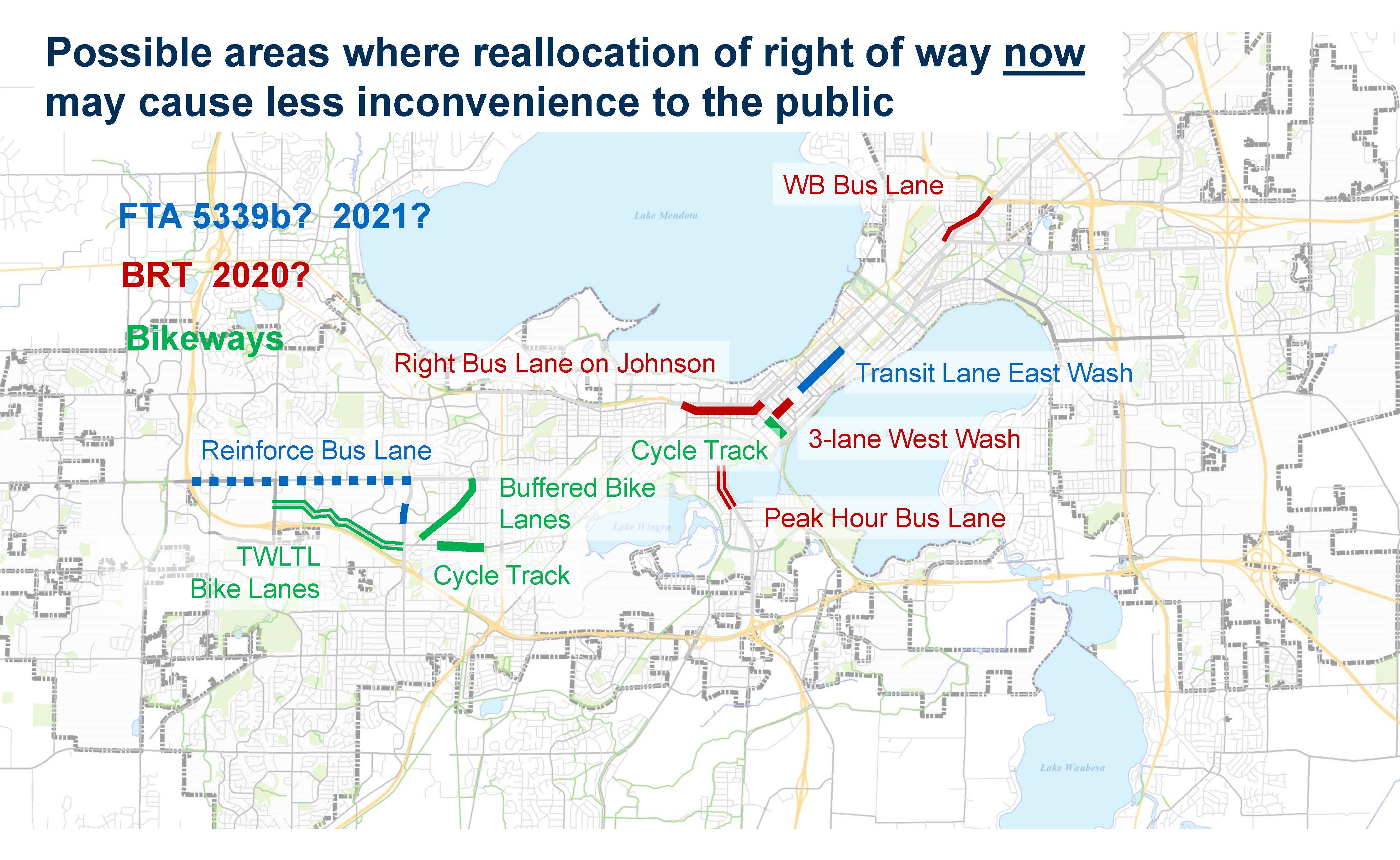
Madison's Department of Transportation (MDOT) took heed, and by mid-April had developed a set of plans that was approved by one of its oversight committees. Those plans identified specific street blocks for alterations that would temporarily limit their motor vehicle use to emergency vehicles and local traffic only. Bicyclists and pedestrians could use street space safely. MDOT's longer range planning committee went further. There had been plans to permanently convert certain roads into bus-only lanes, bicycle ways or wider sidewalks sometime in the future in an effort to sustainably (both socially and environmentally) accommodate Madison's continued growth and development. Initial focus was primarily on the more central parts of Madison. Madison's recently updated Comprehensive Plan of 2018 had the unspecific 'land use and transportation' goal that "Madison will have a safe, efficient, and affordable regional transportation system that offers a variety of choices among transportation modes." The Plan's additional transportation module Madison in Motion similarly stated that the community had need for a "more walkable, bikeable, and transit-oriented city." These documents along with the Regional Transportation Plan 2050 and the 2013-2017 Transit Development Plan were folded together by MDOT's Director Tom Lynch into a presentation at the 2018 Mayor's Neighborhood Conference called Transportation in 2025. Given the relative lull in traffic caused by COVID-19 pandemic, it made sense to try to institute some of those changes earlier than initially planned. Doing so would minimize disruption.
In the end however, actual action was timid. At it's June 24, 2020 meeting, the Transportation Commission only approved two proposed bus lane conversions: one on West Johnson St. between Orchard and Francis Streets and the other on East Washington Ave. between Highway 30 and Seventh St., only two of the red lines shown in the map above. None of the green or blue lines on the map were even proposed.
Dedicating even two street lanes now for buses only is bittersweet however. It is bitter because it has long been known that an obvious way to spare buses from the stranglehold of congestion is to allocate them a street lane. Yet that had never been done for the regular bus outside of a short span of University Ave. bordering the UW-campus some decades ago. Rather, Madison's transportation planners have continued to focus almost exclusively on eliminating bus stops in the name of speeding up the bus. It is easier to hurt bus riders than car drivers. Unsurprisingly, the result has been a deterioration of service and a downward spiral. People lose their bus stop, feel disrespected, and start driving a car instead if they can. That in turn further clogs roads, slows down traffic even more and motivates another round of eliminating bus stops. In the end, the only bus riders left are those who have no choice but to put up with bad service for more reasons than can be enumerated here. Enter a magical new type of bus system called Bus Rapid Transit (BRT) however and the rules change. All of a sudden there are plans for dedicated lanes among other things (such as frequent headways). Bus riders had been used to putting up with crawling along in heavy traffic but that is presumably unacceptable for a supposedly rapid BRT bus. The sweet part of having dedicated lanes is that regular as well special buses will be able to use them. There are still a lot of unknowns and issues to be ironed out including whether car traffic or the regular bus will ever get back to fuller capacities. Beside issues stemming from the pandemic, there are signs that even regular bus routes may get more streamlined although land use planning would need to support that. Currently, it does not. But reallocating road space for transit use only is definitely a step in the right direction. A next step is to recognize that the need for a more people-oriented infrastructure is just as great in areas away from downtown as in the central parts of Madison depicted in the map. Many of those areas are both lower income and more dependent on costly car use. True 'transportation equity' involves applying a set of criteria that produces a similarly more people-friendly land use throughout Madison. |